Waking, hiking and trekking on SYROS
GENERAL
INFORMATION
LINKS SYROS
WALKS
(last update on the 12th of December 2022)
*** = very beautiful
**** = exceptional
+ Gpx = with Gpx-file
2. Chalandrianí - Kastrí and back *** + Gpx
4. Ermoúpolis - Panachrántos - Richopó - Platý Vouní - Glysoúra - Kastrí - Chalandrianí ***
5. Ermoúpolis - Panachrántos - Richopó - Platý Vouní - Glysoúra - Kastrí and back ***
6. Kámbos - beach of Lía and back
7. Kámbos - Cape Diapóri and back *** + Gpx
8. Kámbos - Gría Spília - Grámmata and back *** + Gpx
9. Kíni - Delfíni - Varvaroússa and back *** + Gpx
10. Kómito - lighthouse of Viglostási and back
11. Papoúri - Aetós and back ***
Just like the island of Pàros, also Sýros (or Sýra, as it is called by the inhabitants) can be regarded as the centre of the Cyclades. The capital of Ermoúpoli is in fact the administrative capital of the Nómos (prefecture) of the Cyclades.
Sýros is located in the middle of the northern Cyclades, and more specifically between the islands of Kéa - Kýthnos - Sérifos - Sífnos (the extension of the peninsula of Attika) on the one hand, and the islands of Andros, Tínos and Mýkonos (the extension of the mountain ridge of the elongated island of Evia or Euboia) on the other hand. The harbour of Ermoúpoli therefore functions as the central point of these northern islands.
Sýros
is situated on the busy shipping route to Mýkonos: it is to be reached
easily from the harbour of Piraeus, the main port of Athens - there
are a number of connections every day with the Highspeed-boats and also
modern ships such as the Blue Star Ithaki.
Sýros is also the port from where the Aqua Jewel
and
the
Artemis
(successors of the small Panagía Chozoviótissa and the Panagía Tínou)
depart to many other Cycladic islands. They take care of connections with
Náxos and Páros, Sérifos, Sífnos, Mílos and Kímolos or with Kýthnos,
Kéa and Laúvrio; they even bring you to the islands of Síkinos, Folégandros,
Santoríni and Anáfi and this throughout the year.
In many regards Sýros is an atypical Cycladic island. First of all, the capital of Ermoúpoli counts 14,000 inhabitants (in 1991) which turns it into the largest city of the Cyclades. Despite its rather small surface area of 84 km², the island of Sýros is also the most densely populated of the 24 inhabited Cycladic islands – the number of inhabitants (19,870) largely exceeds the island of Náxos (14,840), which is five times as big.
From all Cyclades, Sýros is the only island with some real industry: starting with shipbuilding, also other kinds of industry prospered, mainly in the years 1860 - 1870. In 1856 already the well-known “Greek Steam Company” was established at Sýros and in the following years thousands of ships were built on the shipyards of Sýros. As a result, Ermoúpoli became the most important commercial and industrial centre of Greece; it was the largest harbour in Greece until the construction of the canal of Corinth (in 1893), which led to the revival of the Piraeus.
Ermoúpoli is not only the largest agglomeration of the Cyclades, also the road network is the densest of all of the islands. This is especially striking in the south of the island, the so-called Káto Meriá, the area south of the imaginary line connecting the deep bays of Ermoúpoli on the east coast and Fínika on the southwest coast. The north, the Ano Meriá, is clearly less urbanised – that is the region where we find the higher hill tops of the Sýringas (434 m) and the Pýrgos (442 m); over there we also find the most important hikes.
Sýros also distinguished itself because of the large cultural flourishing in the 19th century, with figures such as the author Roïdis or the poet Vikélas. The first gymnásio of the independent Greece was established at Sýros, in the year 1839. Also the theatre of Apólloon, a smaller image of the Scala of Milan, played an important role in the cultural bloom.
In contrast with the history of the last two centuries, the early
history of Sýros did run parallel to the other Cycladic islands. The
island knew a remarkable Cycladic bloom in the years 3200 - 2000 B.C. with
archaeological sites in Kastrí and Chalandrianí (in the north of the
island). Sýros did not play an important role in the Classical era, but
it did revive in the Hellinistic era (4th century B.C., archaeological
findings in Grámmata).
After the 4th crusade, in 1204, Sýros was, just like many other islands,
annexed by Marco Sanudo, the Latin duke of Náxos. Ano Sýros was founded
in that period: you can still notice a lot of Venetian influence in the kástro.
In those days, the island also became a bastion of Catholicism, which
earned the island the nickname of “island of the pope”. Even after the
conquest by the Turkish in 1537, the catholic influence remained strong,
thanks to special treaties between the sultan and the French king; the
religious orders of the Jesuits, the Capuchins and the Ursulines were
flourishing.
During the war of independence exiles from, amongst others, Asia Minor
found refuge on the island and in this way the town of Ermoúpoli was
founded, situated closer to the coast than Ano Sýros.
Ermoúpoli did not exist before the Greek revolution and it was
only founded in the years 1820 as an extension of the ancient Ano Sýros.
In the course of a few years, the amphitheatre-shaped landscape, dominated
by two hills, became the setting of a modern city, with a harbour, banks,
schools, printers, theatres and many classicistic buildings that still
give the city an imposing and grand character. In 1829 already, Ermoúpoli
counted 13,000 inhabitants, of which one third were refugees. The
Anástasi-church,
dominating one of the hills of the city, dates from 1824. The stately town
houses really give Ermoúpoli a 19th century appearance. This is mainly
the case close to the large square of Miaoúli, one of the biggest squares
in Greece, with the impressive town hall. It is very pleasant to walk
around in the adjacent streets, with the remarkable Appollo-theatre
(1862-1864) and the church of Agios Nikólaos (1848). In order to reach the
church of Anástasi, the mitrópoli of Syros (dating from 1824) you have
to climb up to the top of one of the hills.
Still a little disconnected from Ermoúpoli, the ancient Ano Sýros
is situated on the other hill and it is dominated by the catholic church
of San Tsorízi (Agios Geórgios). There are a number of other
catholic churches and lower on the hill you find a typical Cycladic town,
with lots of narrow alleys and small staircase streets.
The other side of the large bay of Ermoúpoli is dominated by the Neório,
the large shipyard built by the Greek Steam Company in 1860.
It seems as if international tourism has not yet discovered Sýros, but Greek tourists like to come to Syros, because of the atmosphere in Ermoúpoli and because of the great beaches, especially to be found in the southern half of the island. In particular the towns of Galissás, Fínikas, Posidonía and the smaller Kíni – all of which situated on the west coast -, and also Vári, Méga Gialós and Azólymnos on the southeast coast possess some very attractive beaches.
Traces of settlements from the Bronze Age (3200 - 2000 B.C.) are to be found on the height of Kastrí (only reachable on foot) and in Chalandrianí (with more than 600 tombs).
Especially the northern half of
the island is ideal for hiking, since this part of the
island still has a wild character and is sparcely populated. Some of the
hikes are even numbered and they can be found on the very decent map of Anávasi
– to a lesser extent also on the less detailed Road-map no.104.
The numbers of the hikes, also taken over on the Anávasi-map, are ordered
in a strange way, namely 5 hikes with a red-white indication, 6 hikes with
a yellow-white indication and then another 6 "green" hikes,
without indication. In the field, the trailmarkers are very limited, while
a couple of hikes – such as the one departing from Chartianá – cannot
be found at all.
These hikes are really a must:
- the long, but really beautiful hike from Ermóupolis to Kastrí and
Chalandrianí (a succession of the red-white hikes no. 1, 2 and 3 and the
green hikes no. 1 and 2) or the variant of this hike to
Kastrí and back
- the very lonely hike from Kámbos to the northern cape of Diapóri (the
red-white hike no. 5)
- the hikes to the beach of Grámmata or to the
beaches of Varvaroússa and Aetós.
Since January the 1st 2004
you are visitor n°
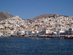
Panoramic view of
Ermoúpoli
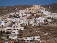
Panoramic view of Ano Sýros
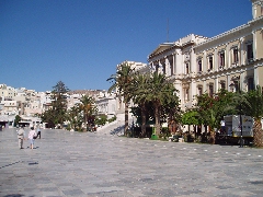
Miaoúli square in Ermoúpoli

Panoramic view on the
bay of Ermoúpoli
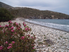
The beach of Lía
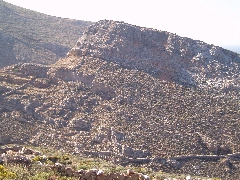
The akropolis of Kastrí
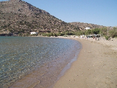
The beach of Galissá
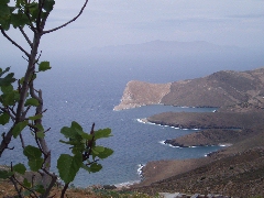
The western coast of Sýros
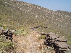
The monopáti to
Diapóri
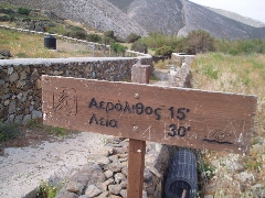
The walking sign on the path to
Lía