2001, 2006, 2007, 2008, 2009,
2012, 2013, 2015, 2017, 2021
and 2024.
Walking, hiking and trekking on SERIFOS
GENERAL
INFORMATION
LINKS SERIFOS
BOATS SERIFOS
MAPS
WALKS
(last update on the 21st January 2025)
*** = very beautiful
**** = exceptional
+ Gpx = with Gpx-file
1. Agia Marína - Agia Thékla - Kefála - Karavás and back
2. Agia Thékla - Liómantra - Avessalós and back
4. Chóra - Gýftika - Profítis Ilías - Ríki - Koutalás
6. Chóra - Gýftika - Protórgia - Vársamo - Panagiá - Gýftika - Chóra *** + Gpx
7. Chóra - Páno Stavrós - Kallítsos - Moní Taxiárchoon - Vounáki - Páno Stvrós - Chóra*** + Gpx
8. Chóra - Páno Stavrós - Kallítsos - moní Taxiárchoon - Galaní - Panagiá
- Chóra
9. Chóra - Páno Stavrós - Vounáki
- Moní Taxiárchoon and back *** + Gpx
10. Kallítsos - Profítis Ilías - Triantáfyllos - Panagía Skopianí - Kallítsos ***
11. Livádi - Agios Ioánnis - Psíli Ammos - Livádi
13. Livádi - Chóra - Psilí Ammos - Livádi
14. Livádi - Livadákia - Rámmos - Kaló Ambéli and back
15. Panagiá - Sykamiá -
Galaní *** + Gpx
16. Panagiá - Vársamo -
Panagía Kamarotí and back *** + Gpx
17. Panagiá - Vársamo - Panagía Kamarotí - Pyrgí and back ***
18. Pýrgos - Galaní - Sykamiá - Skála and back **** + Gpx
19. Pýrgos - Galaní - Sykamiá - Panagiá - Pýrgos ***
20. Sykamiá - Vatoúdi - Pyrgí and back ***
21. Xemónia - Aspros Pýrgos - Koutalás and back
Sérifos
is situated between Kýthnos and Sífnos. Its surface area is 75 km2 and
the population consists of about 1100 people.
The boat line from the
Piraeus which first goes to Kýthnos, also brings you to Sérifos and Sífnos; you reach the port of
Sérifos, Livádi, after a boat trip of about
4 hours.
It is the Adamántios Koraïs that takes care for this line.
In Summer there are also quick trips with the
High Speed.
The Artemis
takes care, three times a week, for a connection between Sýros and Páros, Sérifos, Sífnos and Mílos.
Sérifos is especially attractive because of the beautiful location of Chóra, and because of some very picturesque villages and really nice beaches.
Livádi
is
the name of the port of arrival and from this village the beautiful beach
of Livadáki is in easy reach. There are busses to connect Livádi with Chóra
and a few times a day some busses continue to other villages in the
interior of the island. Chóra,
which is the main village, can be reached via a nice flight of steps as
well. The location of Chóra is really exceptional and the view from the
highest chapel is absolutely great. In
the interior of the island you can also visit Panagiá
(with a one thousand-year-old-church), Galaní
and Kallítsos
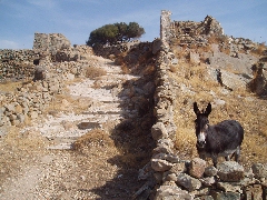
(Kéndarchos). In between
Galaní and Kallítsos there is the wonderful monastery Moní Taxiárchoon, which dates from the 1500s.
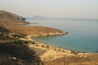
Nice beaches are to
be found in Livadáki, in Psilí Ammos, in Agios Ioánnis (on the east coast),
and also at Koutalás and Méga Livádi in the southwest.
Sérifos
offers a
couple of very nice hikes: there is the fairly long hike from Chóra, via
Kallítsos, Galaní and
Panagiá and then back to
Chóra. There
are some beautiful alternatives, though, to Agios Ioánnis and Psilí Ammos.
The hikes no.4
and 5 in the valley between Galaní, Panagiá and the bay of Sykamiá are
also marvellous.
For a short time now
there are about
eight hikes on the island of Sérifos which are
very well indicated and signposted. In the summer of 2007 we could even
claim that the best indicated hikes of the entire Cyclades are to be found
on Sérifos! Therefore, the following hikes are really easy to follow,
even without a route description:
- hike [A]: Livádi - Chóra
- hike [1]: Chóra - Kallítsos (or Kéndarchos)
- hike [2]: Chóra - Gýftika
- hike [3]: Xemónia - Koutalás
- hike [4]: Gýftika - Protórgia - Vársamo - Panagiá
- hike [5]: Panagiá - Sykamiá
- hike [6]: Pýrgos - Galaní - Sykamiá
- hike
[10]: Kallítsos - Profítis Ilías - Triantáfyllos - Panagía Skopianí -
Kallítsos.
There are also some interesting sites that will help you to prepare your
hikes:
*
the
organisation Paths of Greece, that also is present on the islands of Sífnos
and Kýthira, presents a nice site with the 8 signposted hikes, under the
title « Paths of Iron and Stone » - see
http://pathsofgreece.gr/?page_id=1727&lang=en
* there is also the large site
http://www.discover-serifos.com/en/discover/activities/hiking-trails
that gives 20 short or rather long hikes
In spring 2009 a very good and very clear map came out in the series of Terrain Maps.
Since January the 1st 2004
you are visitor n°
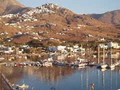
The splendid panoramic view on Livádi and Chóra
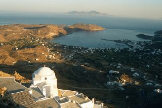
The
view over the bay of Livádi from the highest point in Chóra
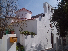
The
church of Panagiá (about 1000 after Chr.)
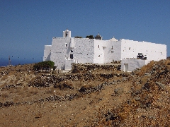
The monastery
of Taxiárchoon
The bays of Psilí Ammos and Agios Ioánnis
The monopáti to Agios Ioánnis