1997, 2007 and 2013
Walking, hiking and trekking on MYKONOS
WALKS
(last update on the 18th of
June 2013)
*** = very beautiful
**** = exceptional
2. Ano Merá - Píthos - Liá - Kalafáti ***
Mýkonos could have been just like any other Cycladic island. However, together with the island of Santoríni, it has developed into thé symbol of the Greek islands in the 70s and 80s. As a result, mass tourism has largely destroyed the traditional atmosphere, particularly during summer. For many years, Mykonos was especially renowned for the very beautiful town of Chóra (exceptionally situated at the seaside) and also as the point of departure to visit the world famous excavations at the nearby island of Dílos. Today, the island is also famous for its bustling nightlife and the beautiful but very busy beaches.
Mýkonos is a rather
small island of only 88 km²; together with Andros and Tínos it forms the
continuation of the mountain ridge of the elongated island of Evia (Euboia).
The island is not very mountainous and the highest summit is the Profítis
Ilías (372m). In 1991, there were 6200 inhabitants.
All year through Mýkonos
can easily be reached, from the Piraeus as well as from Rafína. Leaving
from the Piraeus there is a very busy boat line, via Sýros and Tínos,
taken care of by the Blue Star Ferries (departure around 7.30am and
arrival at about 12.50pm), but also the line to Ikaría and Sámos calls
in at Sýros and Mýkonos (usually with departure at 5pm).
From Rafína as well there are a few connections per day via Andros and Tínos,
usually with departure at 7.30 and 8am and arrival between 12 and 12.30pm.
During summer there are also some frequent connections with High Speed
boats, and connections with for instance Páros, Náxos and Santoríni.
Nowadays, most of the boats arrive in the new harbour, north of Toúrlos,
for the time being still an ugly desert of concrete.
Beautiful findings
from the Archaeological Museum tell us that Mýkonos was a flourishing
centre of the Cycladic (2000 - 1600 B.C.) and also the Mycenian (1400 -
1200 B.C.) civilisation. During the Classical Greek era, however, Mýkonos
was rather insignificant – this in contrast with its smaller neighbour Dílos.
Later, the island followed the history of the other Cyclades, with amongst
others the conquest by the Venetian brothers Gizi in 1207 and the
occupation by the Turkish from 1537 onwards. It was under Turkish rule
that Mýkonos became an important shipping centre and at the beginning of
the Greek fight for independence in 1821 the island possessed 22 warships.
From the ‘50s of the last century onwards, Mýkonos became known as a
tourist centre, mainly because of the magnificent town of Chóra and the
very beautiful beaches. Unfortunately, the development led to a very
dominant nightlife, which means that the best period to visit Mýkonos is
in spring and in autumn.
This hectic tourist
(nigh)life, the presence of the "jet set", the bustle on the
beaches, the numerous restaurant, hotel and bars, all of which might put
off a lot of people. Only read Matt Barrett’s comment (see http://www.mattbarrett.net/spearfishing/index_spearfishing_3.html)
in order to hesitate ever visiting Mýkonos. But in this way you would
definitely wrong the island: Chóra is still very beautiful, particularly
in the morning and in the early afternoon; the beaches are still very
pleasant off season; and in the interior of the island you can still find
some untouched spots – in addition, visiting Dílos is absolutely
worthwhile.
Chóra boasts
one of the most picturesque harbours of the Cyclades
and time and again the jumble of alleys offers marvellous views. The most
popular corners of this probably largest Cycladic town are, amongst others,
the church of Paraportianí, the Mitrópoli, the quarter of Venetiá with
its beautiful houses next to the sea, the Tría Pigádia (three wells,
which, until the ‘50s, formed the only water supply of Chóra), the
mills (Káto Míli) on a dyke close to the sea, etc. From higher up, at
the ring road, and definitely from the highly situated mill of Boni, you
can admire a great panoramic view over the town. Also the museums are
worth a visit, especially the Archaeological Museum, the Folk Museum and
the Museum of the Aegean Marine.
Probably the most
popular tourist attraction is a visit to the nearby island of Dílos.
According to the legend, this island drifted around at sea, until it was
anchored by the gods in order to become the birthplace of Apollo. Because
of the presence of a large sanctuary in honour of this god, Délos (as the
name of the island was written in ancient Greek) flourished already in the 7th and the 6th centuries B.C. In the 5th
century B.C., Délos became the seat of the alliance of the city of Athens, the so-called
Delic Federation. The treasury of this federation was kept in the temple
of Apollo, until it was transferred to the Akropolis in Athens.
During the Hellenistic era, the economic bloom of Délos became even bigger, which
resulted in a population of 25,000 people! This bloom came dramatically to
an end when the island was destroyed by king Mithridates of Pontos in 88
B.C. The island declined completely and once in a while it became a place
of refuge for pirates. The excavations of the sanctuaries and the city
started in 1873.
Today, Dílos is the most important archaeological centre of the Cycladic
isles. To visit the island you have to leave from Mýkonos – weather
permitting the small boats cover the 3-4 km to the holy island in about 30
minutes. The excavations are open from 8.30am to 3pm. There are guided
visits and numerous guides and brochures will help you to explore all of
the archaeological wealth.
In the interior of Mýkonos
there is only one important village worth mentioning, namely Ano Merá;
this is also where the famous monastery of Panagía tis Tourlianís is
situated. This monastery dates from 1542 and it has a remarkably
beautiful clock tower; there is also a truly impressive ikonostási and a
nice museum. There are a lot of churches and chapels in the interior of
the island – 365 as claimed; oftentimes they are built as votive
offerings by seamen of the island, sometimes also as burial places.
In the northern part
of the island the most famous beaches
are the beaches of Toúrlos and Agios Stéfanos, north of Chóra, and
the beaches of Pánormos and Fteliá at the bay of Pánormos. Especially
the beaches in the south, though, have known a cosmopolitan development:
the beaches of Ornós, Psaroú, Platýs Gialós and Paránga, and
definitely the ones of Paradise, Super Paradise, Eliá and Kalafáti. The
beaches of Paradise and Super Paradise, which used to be only reachable by
small boats, are now also connected by a bus line and they are very
popular with naturists and gays.
With regard to hiking,
there is not a lot to do at Mýkonos. The main explanation is that
this barren island was never very fit for agriculture, which means that
there are not a lot of donkey trails. But still, hiking is an ideal way to
discover a few remaining authentic corners of the island – the hike from
Ano Merá to the beach of Liá is really worthwhile.
Since January the 1st 2004
you are visitor n°
On March 25th 2010 visitor n° 100 000 was on this site!
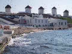
The famous line of
mills on Mýkonos
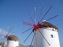
A detailed
picture of the mills
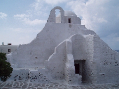
The church of
Paraportianí in Chóra
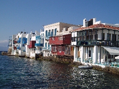
Little Venice
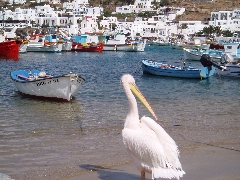
The pelican, the symbol of Mýkonos
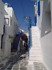
A typical street in Chóra
Ta Tría Pigádia
in Chóra
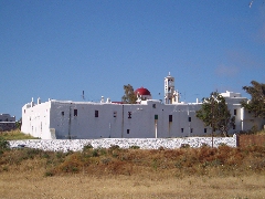
The Panagía tis
Tourlianís in Ano Merá
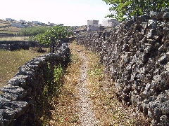
The monopáti to
Liá
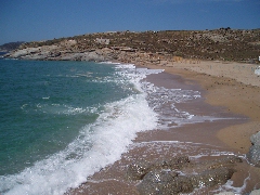
The beach of Liá