2000, 2004, 2010, 2012
and 2019
Walking, hiking and trekking on Mílos
WALKS
(last update on the 10th of February 2022)
*** = very beautiful
**** = exceptional
+ Gpx = with Gpx-file
2. Agia Marína - Profítis Ilías and back ***
3. Agia Sofía - Kléftiko and back *** + Gpx
4. Fylakopí - Papáfranga - Páchaina - Agios Konstantínos - Mýtakas - Sarakíniko - Mandrákia ***
5. Klíma - Pláka - bay of Pláthienas
6.
Mandrákia - Sarakíniko - Mýtakas - Agios Konstantínos - Páchaina -
Papáfranga - Fylakopí *** + Gpx
Mílos is a volcanic island in the south-western corner of the Cycladics. The surface area is 151 km˛, and the island is inhabited by some 4 300 people.
The boat line from the Piraeus, which first calls at Kýthnos and then at
Sérifos and Sífnos, continues to Kímolos and Mílos
- this line runs three times a week, with the Adamántios Koraďs. It then
continues to Folégandros, Síkinos, Ios and Santoríni.
There are also, from April to October, High Speed boats, like the
Speedrunner III or the Seajet.
By ordinary
ferry you reach the harbour of Adámas on Mílos after about 7-8 hours. When
you take the High Speed it only lasts 3,5 hours.
Another
interesting boat connection goes from the Piraeus via Mílos to Santoríni
and
Anáfi and further
to Kássos,
Kárpathos, Chálki and Ródos - for the moment it is the Prevelis, which
takes care of this connection.
There are finally also some connections with the Aqua Jewel and the
Artemis: in this way, it is possible to go to Náxos, Páros, Sýros and
even to Tínos.
Very striking on Mílos
is the large bay of Adámas, the biggest natural harbour in
Greece and maybe one of the safest anchorage places in the entire
Mediterranean. The town of Adámas is very lively, with a busy quay and
with many bars and restaurants, but besides this it does not offer many
places of interest.
The most attractive
aspect of Mílos is probably its variety of coasts, with marvellous rock
formations. Sarakíniko is a wonderful spot on the north coast,
with a kind of moonscape of white, polished rocks – this is quite a
unique place to go for a swim! Also the gorge of Papáfragas, a
small beach in between two high cliffs, is a must to visit. On the south
coast there is a succession of impressive rock coasts: the bay of Gérontas,
the beaches of Firipláka and Tsigrádo, the volcanic beach of
Paleochóri with its marvellously coloured cliffs, etc. Some of the
most amazing spots can only be reached by boat, which means that a day
trip to sail around the island is a must as well. This is the only way to
see the rock formations of Glaroníssia, Arkoúdes, Sikiá
or Kléftiko from nearby – you can even swim on some of these
places.
A very typical
aspect of Mílos is its small harbours with boat garages. Nowadays they are
often converted in summer houses for Greek tourists, but they are still
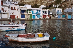
very picturesque. The most beautiful of these harbours are probably Klíma
and Mandrákia, but also Skinopí, Fourkovoúni and Firopótamos are
worth a visit.
A very interesting
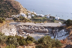
spot is the hill above Klíma, where you can visit some catacombs and even
the remnants of a Roman theatre. Near this place the Venus of Milo was
found in 1870, a statue that can now be admired in the Louvre.
And finally there is
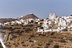
the capital Pláka, which is another wonderfully situated Cycladic
town. On this highest top there are remnants of a Franconian kastro and
there is also the cathedral of the Panagía tis Korfiátissas,
marvellously located on the edge of the high cliffs: both of these places
offer incredible panoramic views and great sunsets.
From Adámas there
are good bus connections with Tripití via Pláka, with the beach of
Paleochóri and with Pollónia, a harbour on the north-east coast from where
there are boat connections with the island of Kímolos.
But in order to discover the most interesting places on this island within
reasonable time it is a good idea to rent a car – although we can
absolutely recommend the boat tour around the island.
Mílos is not an ideal island to hike. As far as we know, the only really ancient trails are the ones in between Pláka and Aretí and in between Klíma and Pláka, but these routes are not that interesting compared to the magnificent old trails on the other islands. The routes along the splendid coast between Mandrália and Fylakopí and especially the site of Sarakíniko are really beautiful, but often, there are no real trails. Also the trail up to the Profítis Ilías is a nice walk...
In 2009 appeared a very good map of Mílos and Kímolos in
the Terrain Maps series.
Since January the 1st 2004
you are visitor n°

The little port of Klíma

View to Tripití and Pláka

The Roman theater above Klíma

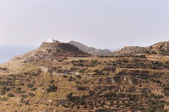
The hill of the Profítis Ilías with the excavations