Walking on KASTELLORIZO or MEGISTI
LINKS
MEGISTI
BOATS MEGISTI
- Blue Star Patmos
WALKS
(last update on the 1st of December 2023)
*** = very beautiful
**** = exceptional
+ Gpx = with Gpx-file
1. Megísti - Agia Triáda - Paleókastro
and back + Gpx
2. Megísti - Agios Geórgios tou Vounoú - French path and back *** + Gpx
3. Megísti - Agios Geórgios tou Vounoú - wine presses - Ochyro - Megísti *** + Gpx
4. Megísti - cape Agios Stéfanos and back + Gpx
5. Walk through the port of Megísti + Gpx
Megísti or Kastellórizo is a small island, which is located just 2 km south
of the Turkish coast and 125 km east of Rhodes; it is part of the
Dodekánissos archipelago. It measures only 11.98 square kilometers, with a
length of 6 km and a width of 3 km. The population is just under 500, all of
whom live in the city of Megísti.
The official name is Megísti and, strangely enough, this name means "the
biggest"; this name already existed in Antiquity and has to do with the fact
that this small island is indeed the largest of an archipelago of three
islands, the other two of which are called Ro and Strongyli (the "round").
There are still six islets in the vicinity, but these belong to Turkey. The
name Kastellórizo, which is used most often, is derived from the Italian "castello"
which means "castle"; the second part of the name would be an alteration of
the name "Ro" ... In Turkish, the island is called "Meis".
Megísti is thus the most to the east located inhabited Greek island, but
despite this isolated situation, it has fairly good direct connections with
Rhodes, with some other islands of the Dodekánissos (Tílos, Nísyros, Kos,
Kálymnos), with Agios Andréas on Astypálea and also with Piraeus, which is
570 km away. There are two boat connections per week with Piraeus via Rhodes
(with a Blue Star) and also six air connections per week with Olympic Air,
with a stopover in Rhodes.
The story of Megísti was quite eventful and often linked to that of Rhodes:
in ancient times the island was in the area of influence of Rhodes and,
also in the Byzantine period, it was part of the province of which Rhodes
was the capital. From 1306 onward, it was governed by the Hospital Knights,
who after their expulsion from the Holy Land had established a small state
in Rhodes and the surrounding area.
Around 1440, the island was occupied for the first time by an Islamist
sultan, but ten years later, it passed into the hands of the king of Naples
- until 1512, date on which it was definitively occupied by the Ottoman
sultan Suleiman. It remained in possession of the Ottoman state, with a
small intermezzo of a Venetian occupation, until after the First World War:
it was indeed in 1923 that the Treaty of Lausanne assigned Megísti to Italy,
with Rhodes and the rest of the Dodekánissos. The island had taken part in
the Greek insurrection in the years 1828-1833, but it remained Turkish after
the end of this insurrection.
After the capitulation of Italy during the Second World War, in 1943, the
island remained occupied by the Allies, but in 1947 it passed, just like all
the archipelago of the Dodekánissos, definitively under the Greek
administration.
In the past, Megísti has experienced periods of real prosperity, among other
things because the island was a safe port on the route to the Middle East,
with ports like Beirut. The population for example reached, towards the end
of the 19th century, a level of approximately 10 000 inhabitants! But with
the decline of the Ottoman Empire also began the decline of the island: it
was the beginning of a massive emigration, especially to Australia and the
United States - and, after the expulsion of the Greeks from the Turkish
coasts in 1923, also to mainland of Greece. The population has thus
decreased to a number of 3000 inhabitants - and for the moment, there are
only 500 permanent inhabitants, all in the small town of
Megísti itself.
Because of its red roofs, the
city has the same appearance as for example Sými or Chalkí and a picturesque
quay borders the 3 sides of the port. The most important curiosities are for
example
the Hospitallers Castle, dating from the 14th century, the cathedral of
Konstantínos and Eléni, the old Ottoman mosque, now converted into a museum,
and the old Italian government building (Palazinna della delegazione).
To the west of the city lies Vígla, the highest point of the island (270 m)
and then the Paleókastro, the
ancient acropolis.
Interesting to note is that the film Méditerraneo (1991),
which recounts the adventures of Italian soldiers after the end of the war
and which won the Oscar for the best foreign film, was filmed on the island.
A scene from The guns of Navarone (1961) also takes place in the castle of
Megísti.
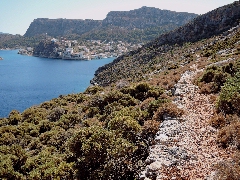
Due to the fact that the island is so small, the walks on
Megísti are quite short, but very pleasant: they will let you walk among
other things along the pleasant seaside towards the northeast point of the
island, with the church of Agios Stéfanos, towards the Paleókastro or
towards the old fortified monastery of Agios Giórgios tou Vounoú.
A handy walking map (Walking Map by Pantazis C. Houlis) is on sale at
Michalis Hatziyakomis' shop on the waterfront.
In
February 2021, the publisher Terrain Maps published a good map of
Kastellórizo: the paths are well
indicated,
on the back there is a short description of
5
walks and there is also a map of the town.
These walks are:
1. To the monastery of Agios Geórgios tou Vounoú and the ancient tombs
2. To the Paleókastro, the Cyclopean wall and the monastery of Agia Triáda
3. To the northern cape of Agios Stéfanos
4. To the monastery of Agia Triáda, the Cyclopean
wall, the chapel of Agios Ioánnis, the "French trail"
and the Gulf of Návlakas
5. To the southern cape of Pounénti.
A boat trip to the famous Blue Grotto is also very
pleasant.
Since January the 1st 2004
you are visitor n°

General view

The
waterfront

The mosque

The blue cave

The French road
The monopáti to
Agios Stefanos