Walking, hiking and trekking on KYTHIRA
BOATS KYTHIRA
-
Vintsentsos Kornaros (LANE)
WALKS
(last update on June the 8th, 2016)
*** = very beautiful
**** = exceptional
2. Avlémonas - Aï Giórgis sto Vounó and back
3. Chóra - Kapsáli - Chóra ***
4. Chóra - Ano Strapódi and back
5. Mitáta - Mávri Spiliá - Agia
Spiliótissa -
water-mill - Mitáta ***
6. Mylopátamos - Píso Pigádi - Káto Chóra - Mylopótamos
7. Mylopátamos - water-mills - Mylopótamos ****
8. Potamós - Trifylliánika - Paleóchora
-
Zaglanikiánika - Agios Níkoon - Potamós ***
Kýthira is situated between Crete and the southeastern tip of the
Peloponnese, but still it is considered as one of the Ionian islands,
which lie mostly to the west of the Greek mainland, in
the Ionian Sea.
In antiquity however, the island was counted among the Cyclades.
Administratively, Kýthira form with the sister island of Antikýthira a large
municipality, part of the region of Attica, although it is very distant
of that part of Greece...
The area of Kýthira is 279.5 km2, but the total population does not
even reaches 4000 inhabitants (2001), which corresponds to a density of
less than 14 per km2.
In 1864, there were still 14500 inhabitants, but since then there has
been a steady immigration, not only to the Greek mainland (Athens), but
also to foreign countries (the United States, Australia and Germany).
In mythology, the island of Kýthira is known as the birthplace of the
goddess Aphrodite or Venus - although this honor is usually reserved for
the island of Cyprus.
In the history of painting, the island is quite known because of the
painting "The Embarkation for Cythera," painted in 1717 by the French
painter Watteau - it is this painting that there is an image of the
goddess Aphrodite…
In antiquity, the island had already in the Minoan period (the peak of
the island of Crete) commercial contacts with Egypt and Mesopotamia,
later there was a Phoenician colony on the island.
In the Classical and Hellenistic periods, Kýthira alternately was under
the domination of Sparta or Athens, but after a period of independence,
the island was incorporated into the Roman Empire - and for many
centuries, Kýthira would remain a part of the Roman or Byzantine empire.
After the weakening of Constantinople because of the 4th Crusade (1204),
the island was occupied by the Venetians: from now on, it was called
Cerigo and remained Venetian, even when most of Greece was occupied
by the Turks.
However, there has been this terrible period, when the Turkish admiral
Barbarossa invaded the island in 1537: during this attack, the ancient
capital of Paleochóra was completely destroyed and most of the
inhabitants were slaughtered or sold into slavery.
From 1797, when Napoleon put an end to the existence of the Venetian
Republic, Kýthira was a part, for a short time, of a French department,
but later it came successively under Turkish, Russian (!) and British
rule - but ultimately, Britain ceded the island to King George 1 of
Greece (May 28, 1864).
The relief of Kýthira is fairly mountainous: the island is indeed
crossed by two mountain ranges; in the west, there is a range of heights
of over 400 meters, with as highest point the top of the Mermigáris (506
m); in the east, there is along the northeast coast a second chain, with
as highest peak the Digenís (489 m). Between the two chains, there is a
plateau with lower heights of 300 meters; on this plateau, one could
have the impression that the island is rather flat - but even here,
there are steep gorges that have been carved into the limestone soil.
In 1972, an airport was built on the island and it was renovated in
1998;
there are daily flights to Athens.
From the port of Diakoftí,
there are boat connections with Piraeus, Antikythíra and Kíssamos on
Crete (3 times a week, with the Vintséntsos Kornáros), and also with
Gýthio, Kalamáta (once a week) and Neápolis (almost every day), in the
Peloponnese.
Because of its location, halfway Crete and the mainland of Greece,
Kýthira was an important crossroads for navigation in this part of the
Mediterranean, but nowadays, the only important activity is tourism -
although Kýthira
is still
untouched by mass tourism.
The island can be considered as a hidden gem, not only because of the many
beautiful views, with lots of greenery and water, but also because of
the many picturesque villages, interesting churches and monasteries and
splendid beaches.
There are no less than 64 villages, from which
Potamós is the largest (396
inhabitants in 2011): the village has a lovely square where on Sunday
morning a lively market is held.
The capital of the island is
Chóra (267 inhabitants), in the south: there is a Venetian castle,
built in 1503, and it enjoys a wonderful view of
Kapsáli, with its double bay
and beaches;
the latter village is quite tourist, with its hotels, restaurants and
two small fishing ports.
Avlémonas, located on the southeast
coast, is also quite lively: this village also possesses a small castle,
but there is especially the beautiful and rather close beach of
Paleópolis.
The port of the island is
Diakofti, but it has also a splendid sand beach.
The village of Agia Pelagía,
located in the north, is also experiencing a tourism development,
especially thanks to the sandy beaches that lie further south.
And then there is still the quiet village of
Karavás with its beautiful
houses, Mylopótamos from
where you can make a wonderful walk to the water mills, the waterfalls
of Fonissa and the cave of Agia Sofia, the village of
Mytáta that
is located in a very green environment, etc.
Kýthira also has many splendid
beaches and small secluded beaches, which sometimes one only can
reach on foot.
The most beautiful are the beach of Diakoftí, that we mentioned already,
the beaches south of Avlémonas (Paleópolis, Kaladí, Fyrí Ammos), some
beaches on the west coast as Melidóni, Limniónas and Kalámi - the last
two beaches at the height of Mylopótamos -
and the small beaches south of Agia Pelagía.
As it is often the case in the islands, walking is also on Kýthira the
ideal way to recognize the island, especially in the months of April-May
and September-October.
This is indeed the best way to get acquainted with nature - waterfalls, gorges,
flowers - and with castles, churches and monasteries.
Here we should mention two Dutch couples: they have not only a beautiful place
of accommodation, but they also organize walking holidays.
Frank van Weerde and Thom Schults live on Kýthira since 2003 and opened
in 2010 the Pýrgos House in Potamós: they organize hikes, partly
accompanied by Frank, who published "Kýthira on foot," a booklet with 32
walks - see
http://www.pyrgoshouse.com/en/#.Vvz3zUdqI3Q
Albert and Anita have the guesthouse Xenónas Fos ke Chóros and also
offer opportunities for hiking - see
http://agreekisland.com
Since Januari the 1st 2004
you are visitor n°
oThe
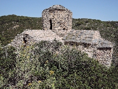
little church of Agia Varvára near Paleóchora
A
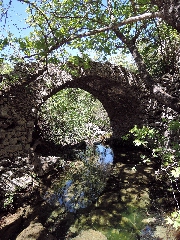
bridge in the valley of Mylopótamos
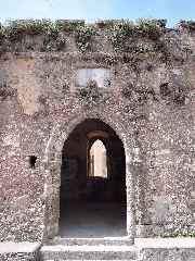
The
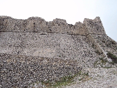
kástro in Chóra
The
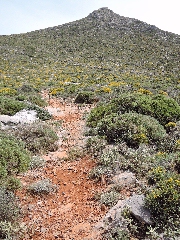
path towards Aï Giórgis
The
English school in Káto Chóra
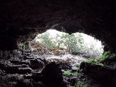
The Black Cave near Mitáta