2014, 2017 and 2024.
Walking, hiking and trekking on KIMOLOS
WALKS
(last update on February 13th, 2025)
*** = very beautiful
**** = exceptional
+ Gpx = with Gpx-file
2. Chorió - Agia Kyriakí - Agii Anárgyri - Chorió
3. Chorió - Agii Anárgyri - Paleókastro - Agióklima and back ****
5. Chorió - Agii Anárgyri - Skiádi - Petalída - Chorió **** + Gpx
6. Chorió - Agii Anárgyri - Sklávos - Agios Vasílios - Profítis Ilías - Chorió ***
7. Chorió - Agios Grigóris - Génnisi Theotókou - Chorió
8. Chorió - Agios Pandeleímonas - Dékas - Mavrospília and back *** + Gpx
9. Chorió - Korakiés - Monastíria - Soúfi and back *** + Gpx
10. Chorió - Livadáki - Pígados - Agios Geórgios and back *** + Gpx
11. Chorió - Psáthi - Chorió + Gpx
12. Chorió - Psáthi - Goúpa - Agios Nikólaos - Klíma - Xaplovoúni -
Chorió
Together
with the island of Mílos and the uninhabited Polúaigos, Kímolos makes up
the group of islands south of Sífnos. The surface area of Kímolos itself
is 36 km2 – with regard to size this island can in fact be compared to
Folégandros, Antíparos or Anáfi. About 730 people live on this island,
of which 500-600 in the capital of Chorió.
Throughout
the year there are boat connections with Kímolos from the Piraeus,
usually with the Adamantios Koraïs. This line first stops on the islands of
Kýthnos, Sérifos and Sífnos, and after a trip of some 6.5 hours you
arrive at Kímolos. From there the boat continues to Mílos,
Folégandros, Síkinos,
Ios and Santoríni.
There are
also
the Aqua Jewel and the Artemis (until 2008 it was the old Panagía
Choziviótissa...), connecting various Cyclades a few times a week, which
brings you from Kímolos directly to Páros, Sýros and even to Tínos,
Andros
and Kéa.
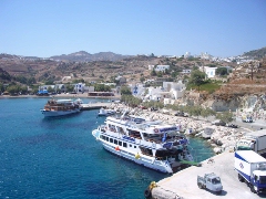
For a fast connection with the other islands you can also take the ferry from Psáthi to Pollónia, on the north-eastern point of Mílos; this ferry – at the moment it is the Panagía Faneroméni – usually makes the crossing 5-6 times a day and the trip only takes half an hour. From the harbour of Milos, Adamás, there are many more boat connections.
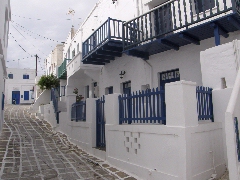
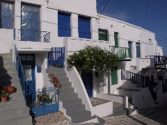
In contrast with its large neighbour Mílos, the little and mountainous island of Kímolos only receives few tourists. Nevertheless, the pleasure boats making - really great - round trips around the islands of Mílos in summer do stop at Kímolos. Chorió and the entire interior of Kímolos have remained very authentic and there is still not a lot of construction on the island. Based on our experience we would argue that at present Kímolos might be the best preserved island of the Cyclades.
Psáthi is the only arrival harbour. It is really a tiny harbour with a few bars on the quay. Chorió is the capital of Kímolos and it is a typical Cycladic village, dominated by the row of mills of Xaplovoúni. There is also a beautiful kástro, of which many houses have fallen into ruins. The south-eastern part of the island is most densely populated and the rest of the island can actually only be reached on foot or via dirt roads. In this south-eastern part you can also find some fishing villages, such as Goúpa and Agios Nikólaos, with the typical boat garages you can also see on Mílos.
Kímolos
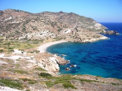
is a great place to hike,
especially on the western half of the island. Although the ancient trail
from Chorió to Paleókastro has partly become a gravel road, there are
still a whole lot of marvellous monopátia around this road, among others
in the mountainous region between the highest summit of the Paleókastro
(364 m), the Profítis Ilías and the Sklávos (358 m). By means of really
great hiking trails you can also walk to the magnificent beaches of Dékas
and Mavrospília or Elleniká.
In 2009 finally appeared a very good map in the series of Terrain
Maps (together with Mílos). This map is very detailed and the hiking trails are
very reliable.
Worth
mentioning is definitely the beautiful website established by teachers and
pupils of the gymnásio in Kímolos, as a result of a project set up by
the school in school year 2003-2004. Next to some historical and
geological information, the site (in Greek and in English) also contains
information on the fauna and flora of the island. Very interesting is a
description of six walks – with very decent maps -, of which one is
located on the nearby and uninhabited island of Polýaigos. See http://gym-kimol.kyk.sch.gr/english/index.htm
Really great walks are: Since January the 1st 2004 you are visitor n°
- the walk Chorió - Agii Anárgyri - Skiádi -
Mavrospília -
Chorió
- the walk Chorió - Agii Anárgyri - Paleókastro -
Agióklima and back
- the walk Chorió - Dékas - Mavrospília and back.
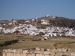
General view of Chorió
with the row of mills on Xaplovoúni
The kástro in
Chorió
The bay of Monastíria
The little harbour of
Psáthi
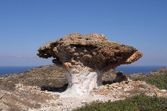
The Skiádi