2011, 2012 and 2017
Walking, hiking and trekking on FOLEGANDROS
WALKS
(last update on December the 27th, 2020)
*** = very beautiful
**** = exceptional
+ Gpx = with Gpx-file
1. Ano Meriá (Agios Andréas) - Agios Sóstis - Agios Geórgios and back ***
3. Ano Meriá (Merovígli) - Agios Pandeleímonas - Ambéli - Vársamo - Ano Meriá (Merovígli)
4.
Ano Meriá (Merovígli) - Livadáki - Asprópountas and back
+ Gpx
5. Ano Meriá (Merovígli) - Livadáki - Asprópountas - Giórgi t' Aga - Angáli - Chóra **** + Gpx
6. Ano Meriá (Stavrós) - Giórgi t' Aga - Agia Paraskevi - Stavrós - Chóra ***
7. Chóra - Petoúsis - Livádi - Loustria - Karavostásis
9. Chóra - Stavrós - Agia Paraskeví - Giórgi t' Aga - Agios Nikólaos and back
10. Chóra - Stavrós - Agia Paraskeví - Giórgi t' Aga - Ano Meriá (Stavrós) ***
12. Chóra - Stavrós - Agia Paraskeví - Giórgi t' Aga - Lighthouse Asprópountas and back ***
Folégandros is a quite mountainous and at first sight desolate island, in the central-southern Cyclades. The surface area is 32 km² and it is inhabited by only 600 people – since the flight from agriculture.
The
boat line from the Piraeus to Kýthnos, Sérifos, Sífnos
and Mílos (with the Adamantios Koraïs) continues
three
times a week to Folégandros, Síkinos, Ios
and Santoríni.
From April
to October,
there is also
a rapid connection
Piraeus -
Sífnos - Mílos - Folégandros -
Santorini and back (with
every day
a departure
from Piraeus
at 7h00
a.m. -
this
line is provided by the Seajet 2 or the Super Jet).
In this way, the harbour of Karavostásis at Folégandros can be reached
after 8-9 hours by means of a regular ferry; when you take the High Speed,
it only takes about 4 hours.
There is also the
Aqua
Jewel, that twice a week makes the connection Sýros - Páros -
Náxos - Folégandros - Síkinos - Ios - Thirasiá - Santoríni – Anáfi, on
Tuesday and Saturday, with return on Wednesday and Sunday.
Finally, there is also the Artemis, that on Friday connects Sýros, Páros,
Náxos, Ios, Síkinos, Folégandros, Kímolos and Mílos – with return on
Saturday...
From the not very
interesting harbour of Karavostásis there are quite a lot of busses to
the main
village
of Chóra, which is situated only three kilometres
away. Chóra is marvellously located on the edge of a staggeringly high
cliff: the best way to get an impression of this location is to have a
look at the sea from the bus square at the entrance of Chóra. Also by
walking to the fairly modern, but marvellously situated Panagía-church (dating
from the 19th century) you can get an idea of the remarkable
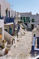
location of Chóra. The town itself is very attractive because there are
many squares with restaurants and terraces, which create a really pleasant
atmosphere. The most beautiful aspect of this town is the kástro. This
is actually a village in the town, an enclosed unit that shows you one of
the most authentic Cycladic habitations. Founded by Marco Sanudo in the
12th century, this kástro is still a very beautiful spot, to be compared
with the village of Kástro on the island of Sífnos.
The other
village, Ano
Meriá, is an elongated community; it is only interesting because it
is the point of departure for many hikes. There is also a Folk Museum that
is worth a visit. A couple of times a day there is a bus connection with
Chora and via this bus line you can also get to the beach of Angáli.
Angáli is the most beautiful beach of Folégandros. From there you can go to the beaches of Agios Nikólaos and Fyrá on foot. You can also go for a swim in the bays of Livadáki, Agios Geórgios, Serfiótiko, Katérgo or Voriná, but you can only reach these places on foot.
With regard to hiking Folégandros is quite interesting. From Chóra you can hike to the beaches around Angáli or to Katérgo and Karavostásis, but especially from Ano Meriá there are plenty of trails to the north-western or south-western coasts. The trail network is quite extensive, so there are many possibilities - the most interesting are
- the walk Chóra - Giórgi t' Aga - Asprópountas - Livadáki - Ano Meriá
- the walks between Chóra
and Agios Nikólaos (also via the beaches of Fyrá
and Angáli
- the two walks from Ano Meriá
to the beach of Agios Geórgios.
There is a good Road map (n° 104) with the islands Folégandros and
Síkinos, with a lot of hiking trails.
But in the course of spring 2009 another map of Folégandros appeared, now
in the series of Terrain Maps: this map is very detailed and gives on the
back side a short description of 8 walks.
Since January the 1st 2004
you are visitor n°
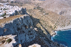
Panoramic view on Chóra
Inside the kastro

The Piátsa, in
Chóra
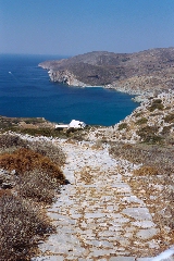
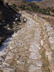
Monopáti to the bays
of Fyrá and Angáli
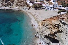
The bay of Angáli
The splendid monopáti to Agios Geórgios