|
Chalkí - Kalóxylos - Moní - Panagía I Drosianí - Chalkí |
||
| Evaluation:
This is one of the most beautiful and most popular hikes on the island
– it is really a must for anyone visiting Naxos. The hike takes you
past some of the most beautiful Byzantine churches, such as Agios Geórgios
o Diassorítis and the Panagía i Drosianí; all the way through the
landscape is wonderfully green and the trails are magnificent. This hike
deserves an evaluation of ***. Estimated time:
The actual hike takes about 60 minutes to Moní and then another 70
minutes back to Chalkí – but as usual, when also taking into account
some periods of rest to marvel at the landscape, you should count on
twice as long in reality. Besides, you should definitely also pay a
visit to the churches of Drosianí and Diassorítis: the first one can
often be visited, fortunately; the second one is not always open (definitely
not on Mondays). Finally, you need some time for lunch as well (at To
Panórama in Moní or a picnic at Drosianí?). This will clearly turn
into a long and magnificent hiking day… Route
description:
If you are taking the bus from Chóra, catching the bus at 9.30am is
quite the right thing to do. When getting off the bus you will see the
church of the Panagía i Evangelístria i Protótronos on the opposite
side. This church contains some beautiful murals and especially a
fantastic ikonostási – unfortunately though, the church is often
closed. Your best bet is on the way back in the early evening, when
relaxing on the terrace of the café Chalkí, near the bus stop. At that
time of the day you might see the papás opening the church in order to
go and sing the vespers. In this way you can enjoy both the treasures of
the church and the priest’s singing!
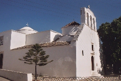
The Panagia i Evangelistria in Chalki. From the bus stop you take the street on the left of the church, by facing the Panagía. This street runs straight to the Pýrgos Grazía; above the entrance you notice the coat of arms of the famous Venetian family Barozzi.
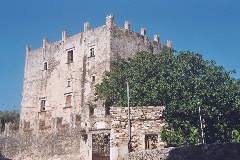
The impressive Pirgos Grazia in Chalki. A little further
you get to a concrete road, which you follow to the right. After five
minutes you can take a right on a paved little street in order to go and
have a look at the (closed) tower of Markopolíti. You then return to
the concrete road and you continue by following the red and blue dots.
Slightly further down you arrive at the asphalt road Chalkí – Filóti,
where you take a right. Already after about 100 metres you take the
small asphalt road off the left (there is also a sign to Kalóxylos). You follow this
road, past the old mill to press oil, underneath the rusty line, and by
curving to the left. You thus pass the large church of Agia Triáda and
you continue through the village in northern direction. On a small
square with a locust tree you take a right (there is a red and a blue
dot) and you follow the meandering Odós Agioon Apostóloon (left, right
and left again), towards the north-east. You walk past a second
beautiful square, you go underneath an arched passage and then the
concrete path becomes narrower. Past the churches of Agii Apóstoli and
Agia Ekaterína, and also past the cemetery, you go over a bridge – a
nice spot with some water – and then to the right. For a short while
the trail turns into earth and then it becomes concrete again. After
five minutes though, the trail is permanently made of earth and it
zigzags amidst beautiful olive fields (there are plenty of red and blue
dots). The trail crosses another stream with water and with lots of
green (on the 16th of May 2004); it meanders up and at a junction you
keep to the right. A little later on you continue on a narrower rocky
trail, on the left-hand side of a wall (with a red dot). You climb up
steeply now and behind you you get a great view on the villages of Chalkí
and Damariónas. A little higher up you get to a junction: despite the
small tree- trunk, which sometimes seems to block the road, you take a
right. This monopáti is densely overgrown, but still it remains visible.
You continue in northern direction all the time – after about ten
minutes you suddenly get a marvellous view on Moní, towards the left in
front of you.
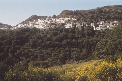
Panoramic view on Moni. You then reach a
concrete road, which you follow to the right for some 200 metres. Over
there you notice a sign to a wood workshop and you follow this earth
road to the left. You go past the turn to the workshop, with a
magnificent view on Moní. You descend steeply on a rocky staircase, and
then you walk horizontally for a short while, next to the deep valley.
You cross the gorge over an arched bridge high above the water and you
go up again. You walk both on steps and on a rock trail, until you get
to the village. When you reach the top you take a right and you thus
arrive at a little square with an oak tree. You go left here, you walk
through the street and then you will see the cars, the café Parádeisos
and the estiatórion To Panórama in front of you. Especially the
outdoor terrace of To Panórama is very pleasant to have drink and the
view is really attractive. From the balcony of the café you can
distinguish the white upper part of the Panagía Drosianí, where you
are heading for. Underneath
you can see the blue dome of the church where the second part of the
hike takes off. |
Especially
the outdoor terrace of To Panórama is very pleasant to have drink and
the view is really attractive. From the balcony of the café you
can distinguish the white upper part of the Panagía Drosianí, where
you are heading for. Underneath
you can see the blue dome of the church where the second part of the
hike takes off. Outside To Panórama
you take a right again, almost to the far end of the street. You then go
down the steps on the right until you get to the left of the church. On
the south-side of the church there is a street off the right. By means
of steps this street describes a wide bend to the left and it thus
leaves the village quickly. You follow this beautiful and sometimes very
large staircase for about five minutes. At the junction you then go
right. The trail continues horizontally for a short while and it becomes
sandy later on. You thus arrive at the left-hand side of the church of
the Panagía i Drosianí.
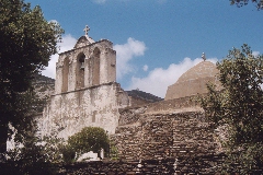
The Panagia i Drosiani. The Panagía i
Drosianí (Our Lady of the Dew – according to the legend the famous
icon of Our Lady gets wet when the region faces danger or a disaster) is
an early Christian church, probably dating back to the 6th century. The
famous fresco’s which you can visit here date from the 6th or the 7th
centuries. Fortunately, the church is regularly open; you can also buy a
booklet (in Greek and English) with some explanations and with beautiful
illustrations of the icon and the fresco’s. From the church
you go down the paved trail, you cross the asphalt road and you continue
on the path straight ahead (there are some clear dots). Your trail
descends nicely and via a steep staircase you reach a small, dry bed of
a stream. You follow this bed to the left for a couple of minutes (there
is also a red arrow pointing to the left). Finally, you walk on the
left-hand bank of the river-bed – not too early though! – and the
monopáti becomes very nice again. You cross a small stream with
water and you go up on the left. You thus continue almost horizontally for some three to four minutes,
until you get to an open space with a concrete slope on the left.
Straight ahead you descend a couple of steps and you continue on the
left-hand side of a wall (with dots). The trail is slightly overgrown (especially
in Spring time); it first runs along a river and it then ends into this
river on a beautiful spot – you follow this dry bed to the left. At this point you should watch out: you should follow this bed with oleanders for exactly six minutes; at the corner of a wall (with a red dot and an arrow) you climb up the sloping rock and you continue on a beautiful trail for another three minutes. You then reach a stretch of gravel road – some 50 metres further down there is a white building – and here you have to go up on the right to the church of the Panagía Rachidiótissa, which is closed however. This is a nice spot though, so very inviting to take some rest. On the right-hand
side of the church you continue on a nice path between walls, (so you DO
NOT go back down). After about 50 metres you curve to the left and
downhill in front of you can - with some difficulties - discern the
ruined basilica of Agios Isidóros. A little further there is a trail off
the right, where from you can see the basilica even better. However, you
have to go straight at this point and you go further down – you thus
stay on the somewhat overgrown path. Some three minutes later you still
keep to the left and you now walk between wonderful, tall oak trees.
After another three minutes you arrive at a clear junction: the trail on
the left leads to the main valley and it thus returns to the Panagía
Rachidiótissa. Obviously, you should take a right; you walk on the
right-hand side of a very tall wall for another three minutes. You then
get to the deserted houses of Rachí and to the church. You then take
the narrow street off the left (there is a red dot). It runs in between
houses and after about two minutes it reaches a black fence. You descend
on the left in the ‘main street’. You continue to go down on
this concrete road, which runs all the way through the village. Across
the bridge the road gets larger and it describes a bend to the right. In
the next bend to the left you go straight ahead on a green path in
between walls (there is a sign). At a junction you take a right, and
further down you go right again on a stretch of turned over land. You
thus get to the marvellous church of Agios Geórgios o Diassorítis (or
Saint George the Saviour), situated amidst olive trees. This church
would be one of the oldest Christian buildings on the island, dating
from the 11th century. Sometimes, the church is open, but
definitely not on Mondays.
The church of Agios Geórgios o Diassoritis. From the church
you return, in the direction of Chalkí: back over the turned over
stretch of land; a little further down you keep to the left (the trail
on the right leads to Tsikalarió) and at the next junction you take a
right. With some difficulties and with wet feet you follow the flooded
path (in May 2004) until you arrive at the church Agia Marína. This
chapel is really built on top of a well with lots of water, even the
floor of the chapel is wet! You take a right here and you follow a
meandering road for the next five minutes – all the way you are guided
by red dots. Just before the village of Chalkí you cross the concrete
road, you go straight ahead and you thus get against the outer wall of
the Ergostásio Kítrou of Vallandris. This is one of the distilleries
at Naxos, where the famous lemon drink is produced. The work place is
worth a visit and you can also buy different varieties of this tasty
drink. Before Vallándris you take a right for a short while, then left
again, and then you have reached the beautiful and very pleasant outdoor
terrace of the most popular tavern of Chalkí: O Giannis. To
get the printer-friendly version |
|