2011, 2013, 2015 and 2018
Walking, hiking and trekking on ANTIPAROS
WALKS
(last update on the 14th of February 2021)
*** = very beautiful
**** = exceptional
+ Gpx = with Gpx-file
1. Agios Geórgios -Agios Sóstis - Faneroméni and back
2. Agios Geórgios - Despotikó - Livádi and back ***
3. Agios Geórgios - Kambiá - Profítis Ilías - Agios Geórgios + Gpx
4. Agios Geórgios - Kambiá - Profítis Ilías - Cave of Agios Ioánnis *** + Gpx
3. Agios Geórgios - Megála Monastíria and back
4. Agios Geórgios - Profítis Ilías - Cave of Agios Ioánnis ***
6. Antíparos - Diplá - Sifnéikos Gialós - Antíparos
7. Cave of Agios Ioánnis - Agia Paraskeví - Antíparos
Antíparos can
easily be reached from Páros: leaving from Poúnta, on the west coast of
Páros, there are crossings every hour (it takes 10 minutes). Also from
the capital Parikiá you can take the boat to Antíparos (this only in
summer and the crossing takes 30 minutes).
The island of Antíparos
is fairly flat; the highest point is the Profítis Ilías, with an
altitude of 301 metres. There are a few beautiful beaches, but the island
is especially renowned because of the cave on a hilltop of 250 m in
the south. Next to the entrance of the cave you can find the small church
of Agios Ioánnis. The cave itself contains three large halls and
it is more than 100m deep. It
is famous because of its huge stalactites and stalagmites, many of which
contain ancient inscriptions. The most famous stalactite is 8 metres tall
and it is called the "Agia Trápeza" ("Holy Table").
This name was given because a mass was celebrated here on the 24th
of December 1673, in the presence of the French ambassador in
Constantinople, marquis de Nointel – a Latin inscription still bears
witness to this event. In turbulent times the cave also provided a shelter
for the inhabitants of Antíparos.
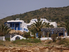 DOLPHIN
APARTMENTS, the perfect place to stay!
DOLPHIN
APARTMENTS, the perfect place to stay!
The capital Antíparos
is built around a beautiful Venetian kástro, dating from the 15th century. The kástro is built around a
tower, of which only the base remains.
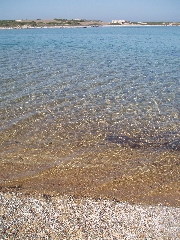
The most famous beaches
are the beaches of Psaralikí, southeast of Antíparos, the beaches of
Agios Theológos (close to the campsite, a few minutes north of the small
town) and the beaches of Sifnéikos Gialós a little southwest of it
– both of which are within walking distance of Antíparos.
In the south there is also the beach of Agios Geórgios, opposite the
island of Despotikó. On the east coast as well there are a couple of nice
beaches, among which the beaches of Apándima and Sóros.
Hiking is
not that easy on Antíparos. There have never been a lot of donkey trails
and the beautiful path that used to run from the cave, to the north and
across the island, to Chóra, has been destroyed by a gravel road already
many years ago – this road has recently been asphalted. Since January the 1st 2004 you are visitor n°
However, the short sea
walk from the northern coast of Antíparos to Diplá is a truly remarkable
experience.
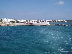
The little harbour of Antíparos

The kástro of Antíparos
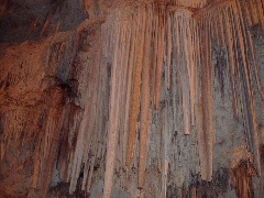
The cave of Antíparos
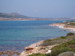
The straits between
Antíparos and Despotikó
The narrow straits between Antíparos and Diplá