2006, 2008, 2010, 2011, 2012, 2013,
2015, 2017, 2021, 2022 (2X),
2023 and 2024.
Walking, hiking and trekking on AMORGOS
WALKS
(last update on the 6yh of December 2024)
*** = very beautiful
**** = exceptional
+ Gpx = with Gpx-file
1. Arkesíni - Agia Triáda - Káto Kámbos and back + Gpx
2. Arkesíni
- Rachoúla - Vroútsi - Kastrí - Vroútsi *** + Gpx
3.
Asfondilítis - Oxo Meriá - Agios Mámas - Potamós - Egiáli **** +
Gpx
4.
Chóra
- Agia Anna - Chóra
5. Chóra - Moní Chozoviotissa -
Asfondilítis - Egiáli ****
+ Gpx
6.
Chóra
- Profitis Ilias - Moní Chozoviótissa - Chóra ***
6.
Chóra - Profítis Ilías and back *** + Gpx
8. Egiáli
- Langáda - Agios
Theologos - Stavros and back **** + Gpx
9. Egiáli
- Langáda - Agios Theológos - Epanochorianí - Tholaria ***
10. Egiáli
- Langáda - mills of Machos - Egiáli
11. Egiáli - Langáda
- Panagía Epanochorianí - Tholária - Egiáli ****
+ Gpx
12. Egiáli - Langáda - Stroúmbos - Panagía Epanochorianí - Tholária - Egiáli *** + Gpx
13. Egiáli - Langáda - Tholaria - Egiáli ***
14. Egiáli - Potamós - Asfondilítis and back **** + Gpx
15. Egiáli - Tholária - Agios Ioánnis - Agios Dimítrios - Tholária - Egiáli ***
16. Egiáli - Tholária and back
17. Egiáli - Tholária - Mikrí Vlycháda and back***
18.
Kamári - Agii Saránda - Agia Thékla and back **** + Gpx
19. Kamári - Agii Saránda -
Agia Thékla - Léfkes - Katápola *** + Gpx
20.
Kamári
- Kastrí -
Agia Thékla - Léfkes - Katápola ***
21. Kamári - Kastrí - Vroútsi - Kamári *** + Gpx
22. Katápola - Chóra - Agios Geórgios Valsamítis- Katápola
23. Katápola - Chóra - hills of Vígla - Katápola
24. Katápola
- Chóra and back *** + Gpx
25.
Katápola
-
dam - Valsamítis - Katápola
26. Katápola - hills of Víglia and Vouní - Agia Varvára - Miliés - Katápola ***
27. Katápola - hills Viglia and Vouní - Chóra *** + Gpx
28. Katápola - Stavrós - Léfkes - Agia Thékla - Agii Saránda - Kastrí - Vroútsi *** + Gpx
29. Katápola - Stavrós - Agios Geórgoios Valsamítis - Chóra *** + Gpx
30. Katápola - Stavrós - Agios Geórgios Valsamítis - Katápola
31. Katápola - Xylokeratídhi - beaches
32. Katápola - Xylokeratídi - Ta Nerá - Vígla - Xylokeratídi - Katápola + Gpx
33. Langáda - Stavrós - Chorafákia - Páno Mántra - Máchos - Langáda ****
34. Langáda - Tholária and back *** + Gpx
35. Vroútsi - Kastrí - Vroútsi - Rachoúla - Agia Triáda - Káto Kámbos - Vroútsi ***
* * *
For the walks on Irakliá, Schinoússa, Páno Koufoníssi and Donoússa, see The small Cyclades
Amorgós
is the most eastern of the Cycladic isles. It is also one of the most
mountainous and until the ‘80s it remained rather isolated without too
many tourists. The surface area of Amorgós is 121 km2 and it is inhabited by approximately 1600 people.
An important boat line connects the Pireus with Amorgós, via Páros and Náxos. This boat makes a detour via the little Cycladic islands of Donoússa, Schinoússa, Irakliá and Koufonísi. Sometimes the boat continues to Astipálea, and in this way a connection is established with the Dodekánissos - amongst others with Kálimnos, Kós and Rhódos. Leaving from Amorgós’ main port Katápola, the small Express Skopelítis establishes a link with Náxos, the little Cycladic isles and the northern port of Egiálli, and this almost daily. It takes about 8 - 9 hours to reach Amorgós from the Pireus.
Until recently,
visiting the island was, for many tourists, limited to the area
surrounding Katápola, to the town of Chóra and to the monastery of
Chozoviótissa. This was mainly due to the lack of decent roads and
reliable bus connections. Nowadays, it is fairly easy to reach the
northern part of the island around Egiáli, and the south around the Káto Meriá
(just a couple of villages), by
car or by
bus. However, the most fascinating way to
discover Amorgós is by means of the ancient monopátia.
Katápola is
the usual port of arrival: there are a couple of hotels and restaurants,
and the camping is nearby. You can walk all the way alongside the bay on
foot to the beaches north of Katápola, or you can cross the bay with a
little boat. On the hillside south of Katápola you can find the
archaeological site of Minoa.
There are busses to connect Katápola with Chóra, and via Chóra also with Egiáli in the north and (in Summer) with the villages in the south.
Chóra
is situated at about 5 km from Katápola; it is a very pleasant Cycladic
town, dominated by a small castle and some wind mills. Sometimes the bus
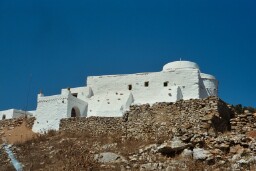
continues to the monastery of Panagía Chozoviótissa and the beach of Agia
Anna, but it is much nicer to make this trip on foot. The monastery is the
most beautiful Byzantine monastery of the Cycladic isles and it dates from
the 9th century. It is bright white and it is located high
against the staggering cliffs. The monks still welcome tourists with a
glass of water, a glass of liqueur and some loukoum.
The northern port of
Egiáli offers a really beautiful beach, but it is also a great
point of departure for the marvellous hikes to the villages of Lankáda and
Tholária. Also the monastery of Agios Theológos is beautifully located and
is definitely worth a visit.
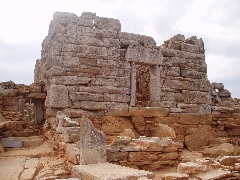
In the mountainous south of the island, especially the akropolis of the ancient Arkesíni (Kastrí) is worthwhile.
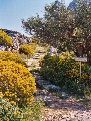
With regard to
hiking, there are still a couple of very old monopátia at Amorgós: you can
hike from Katápola to Chóra or to Minóa, but the queen’s hike is the
longer trip on the mountain ridge of the island, from Chóra to Egiáli.
Also the hikes from Egiáli and from Arkesíni and Kamári are truly
wonderful. In addition, some of these hikes are clearly signposted.
In earlier days, the road map of the
German Georg Perreiter was a really good guide, but some years ago a very
beautiful map has been published by Anávasi. This map contains many hiking
trails, it is almost always reliable and it is for sale on the island. At
the back of the new edition of 2006 there is also a nice map of the
village of Chóra. The scale has now become 1:35 000 instead of 1:40 000.
In the course of spring 2009 another map of Amorgós appeared, now in the
series of Terrain Maps: this map is also very detailed and even more precise
than the Anávasi-map (edition 2006) - especially in the neighbourhood of
Langáda, Megáli Vlycháda and Ta Nerá. On the back side of the map,
there are 14 short descriptions of walks.
Nowadays, you can also get at the town council "A Travelogue of Amorgós", a nicely published little book with historical hiking
trails. In this book there are lots of beautiful maps and some great
pictures (published in Greek or English in 2001 -
since the year 2006, this is also available in French). In this small book
you find a fairy elaborate description of the 6 signposted hikes and it is
now also for sale in the very decent bookshop in Katápola.
It might be
difficult to choose from the 35 variants of hikes offered on this
site. In order to help you, I give my personal top five hereunder:
1. Chóra - Egiáli (hike no. [1])
2. Egiáli - Langáda - Agios Theológos - Stavrós - Egiáli (hike no. [5])
3. Kamári - Kástri - Léfkes - Katápola (part of hike no. [3])
4. Chóra - Profítis Ilías
- Chozoviótissa - Chóra
5. Egiáli -
Langáda - Tholária - Egiáli (hike no. [4])
In the shorter hikes
you should definitely first walk from Katápola to Chóra, which you can
do by following the hike Katápola - Chóra - Katápola (hike no. [2]).
Since January the 1st 2004
you are visitor n°

The monastery of Panagía Chozoviótissa
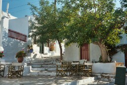
A nice little square
in Chóra
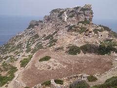
The akropolis
of Kastrí
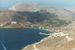
The splendid bay of Egiáli
The monastery of
Agios Theológos
The beautiful monopati to Langáda
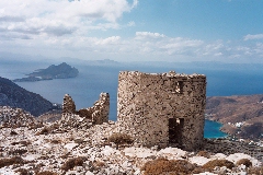
Ruins of two mills high above Langáda
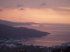
Sunset on the bay of Katápola
The Hellenistic tower of Agia Triáda